Written by: Shehrbano Saiyid - Posted on: July 13, 2012 |  Comments | 中国 (Chinese)
Google Translation: اُردو | 中文

Part I: Passu Expedition
Wazir Aman slumped his 30kg load on the ground, sat down on a rock to catch his breath and gazed at the landscape before him. The Passu glacier spread before us, a white mass of ice and snow, blinding and ominous. We were barely half way up the slope which opened up to the lush green Patundas plateau with its promise of a breathtaking view of two of world’s biggest glaciers: the glistening stretch of the Passu on one side and the dark expanse of the Batura on the other. For Aman, a porter from the small village of Ghulkin, this area was home, and he would dedicate his life to exposing its potential.
Aman was the chief porter for our summit expedition of Passu Peak (7478m), attempted in June 2012. Surrounded by mountains over 20,000ft high, Passu peak looms over the fast moving and heavily crevassed Passu glacier that rises above the Karakoram Highway in the Gojal valley north of Hunza. Aman had organized a team of porters to assist us till base camp. Most of the porters were from his village and unlike the Baltis in Skardu these men carried loads to supplement their main incomes. Most of them had finished school and some had even done their masters. These people were born into a time of rapid development and saw their lives change within a generation. Illiterate farmers gave birth to school teachers and entrepreneurs. But the economy in the great mountain valleys of northern Pakistan was struggling. People lost a significant part of their land in the floods in 2010 and the Atabad lake - created on the Indus River by a landslide in 2010 - makes transport between Gojal and Hunza longer, harder and more expensive. The first half of this year saw an unparalleled level of sectarian violence in Kohistan when passengers on a bus were gunned down in Chilas, the conservative capital of Diamer district. Since then few tourists have dared to make the journey. These young porters need to earn whenever they can and their ambitions never discouraged them from hard physical labor.
Reaching their area showed how the economy had suffered over the years. The journey through the mighty Karakorams was long and arduous. We had driven up the Karakoram Highway till the Atabad Lake in a group of 5 people from Islamabad, Lahore and Karachi and were joined by our guide, Karim Hyatt and his team in Karimabad, Hunza. The route through the mountains had changed drastically since my last visit in 2009 – the KKH was mostly a broken dirt track all the way to Danyore. The soil crumbled at the bank of the Indus as steep cliffs of freshly exposed mud and rock rose above the water: a reminder of the damage left by the floods and a warning for the potential damage that could be done in case of another. There was a lot of work left to do. The road needed to be paved; the river banks needed protective barriers to contain any future rise in water levels, and scores of houses were yet to be rebuilt.
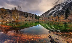
The biggest change through the KKH was the sudden creation of the Atabad lake, breaking the KKH as it snaked its way through the Chinese border. Half an hour north of Karimabad - the historic capital of Hunza - the road became a cloud of dust as jeeps and vans pushed through the soft sand newly exposed after the landslide. Frantically rolling up the windows and covering our nose and mouths to avoid breathing the dust in the air, we turned a corner to catch first sight of the lake. There was complete silence as everyone gazed out the window at what they saw. An endless expanse of turquoise water stretched before us, shimmering in the bright glow of the morning sun as it curved behind the mountain ridge in the distance and disappeared. How could something so beautiful destroy so many lives? Almost half the village of Atabad had fallen into the river with the landslide in 2010; thousands of households in Hunza and Gojal had lost their homes and were living in temporary shelters. A significant proportion of cultivable land had been submerged in the rising waters. The locals were eager to have the lake drained from the south where the landslide had closed off the Indus River, allowing more water to flow into it than out. Draining the lake would give them back some of their land but the people were concerned that the government might maintain the lake and build a road above it leaving the locals to figure out land terracing solutions for growing more food.
Click to view picture gallery