Written by: Haroon Shuaib
Posted on: July 21, 2022 |  | 中文
| 中文
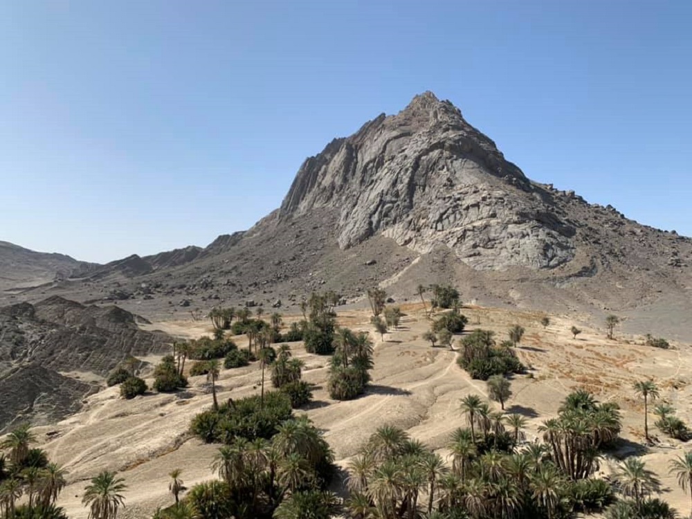
Kharan also has barren mountains and date palm clusters growing at their foothills
Kharan District of Balochistan province, came to prominence when Pakistan's second nuclear test was performed in its desert on May 30, 1998, but the history of the land goes back centuries and well beyond.
During the campaigns of Alexander the Great, Greeks named the southern regions of Balochistan as Gedrosia. During the Sassanid period (7th–8th centuries CE), the regions which today comprise of Balochistan were referred to as Turan, corresponding to present-day Sarawan, Jhalawan, Pradhan (probably modern-day Kharan and Chagai), Makuran and Sakastan (modern-day Sistan). The region has also braved the onslaught of the Persian and Afghan armies over the centuries.
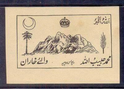
A 50 rupee note of the State of Kharan
According to the historian Istakhari, the ancient name of Kharan was Karan or Qaran, meaning ‘barren mountains. Kharan is a Balochi word which means yellow colour (Yellow Mountain). Koh-e-Kharan is also mentioned in Kitab-i-Masalik-o-Mumalik (by 9th-century Persian geographer Ibn Khordadbeh. The book maps and describes the major trade routes of the time within the Muslim world, and discusses distant trading regions such as Japan, Korea, and China). The oldest documented history of the region can be found in the The Imperial Gazetteer of India. The Gazette writes: “Little is known of the history of the country previous to the end of the 17th century when Ibrahim Khan, the Nausherwani Chief of Kharan, served the Chilzai Dynasty of Kandahar, except that it formed part of the Persian Province of Kirman. The Nausherwani Chiefs, around whom the local history centers, claim descent from the Kianian Maliks, and have always been a race of strong-willed, bold and adventurous men, taking full advantage of their desert protected country for organizing raiding expeditions against their neighbours and professing a fitful allegiance to Persia, to Kalat and to Afghanistan in turns.”
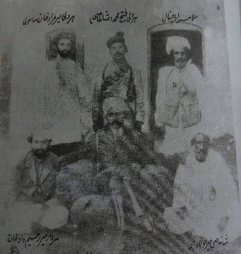
An archive photo of the tribal elders of Kharan
The oral historians of the area claim that the Nausherwani tribe came to Kharan from Iran sometime during the 14th century AD, and made it their home. From Iran, they migrated towards Sistan, bordering the present-day Kharan district under the leadership of Mir Abbas Khan. Mir Abbas married into local Peerakzai tribe and slowly gained control over the region, and eventually succeeded the Peerakzai Chief as the new chief of the area. The ancient fort of Kharan was built many generations later by his scion Azad Khan Nausherwani, who took control of Kharan in 1789. Azad Khan Nosherwani built eleven fortresses around the city to secure it politically from Afghanistan, the State of Kalat and foreign traders. According to a legend, construction of the main fort was stopped many times due to inadequate water supply. Despite numerous efforts, the water crisis made the construction of the fort impossible. Wells and Karez (underground waterways) were excavated many times, but water became impossible to access. A famous spiritual personality who had close ties with the Chief was called upon to help. He took Azad Khan from the present Kharan town to the north to Dilkasha, a famous place at the time, and marked the location of Karez and the fort with his supernatural wand. It is reported that from that time onwards, the water of the Karez has been flowing in the same quantity. With the blessings of the spiritual guide, the construction of the fort was again planned under a new strategy. The fort was architecturally built on the Iranian style layout, where solid burnt bricks were used, and dome shaped structures were built for security measures. It is said that the building blocks for the fort were brought from around six kilometers away through a human chain.
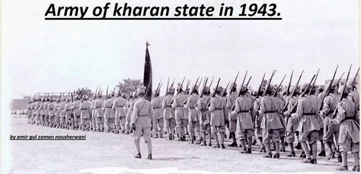
Army of Kharan State in 1943
Seven mysterious domed monuments remain scattered around the region as a testament of the valor of the warriors, who fought many battles in the region. They were previously nine such monuments according to the Gazetteer of 1906, but with the passing of time, two have vanished due to the brutal sandstorms of the desert of Kharan and Chaghai. The seven that remain are also withering and disintegrating fast. Built of burnt bricks, their square decaying double-storied structures, not more than ten meters square, house hundreds of graves. In by-gone times, the exteriors of these buildings were decorated with square tiles of baked clay, adorned with designs, none of which remain.
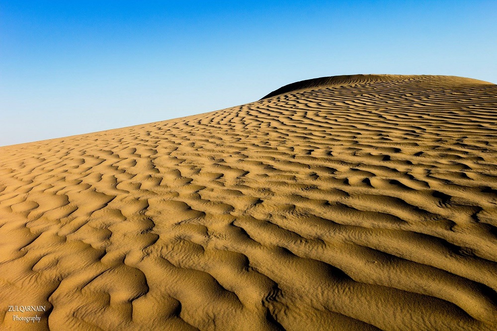
Chaghai-Kharan desert is also known as Golden Desert
According to Salman Rashid, famous archeologist, historian and travel writer, the Nosherwani rulers of Kharan state claimed these compounds as their family burial sites, but a plaque once affixed on one of these graves said, ‘Mazar-e-Nikodar’ (Tomb of Nikodar). Rashid notes that the first ever reference to Nikodar comes from Marco Polo (late 13th century). While crossing the desert region near Kerman (Iran), Marco Polo noted that the villages were strongly fortified against a ruthless bunch of bandits. These bandits possessed magical powers and could bring down darkness upon towns and caravans to plunder them at will and were led by one Nikodar. According to Salman Rashid, “a more logical explanation is that the tombs date back to the late 13th century when a large number of the Nikodari band was slaughtered during a raid into this arid country and were buried here by the survivors. That would explain the multiple burials. Or some pestilence that wiped out most of the marauding army”.
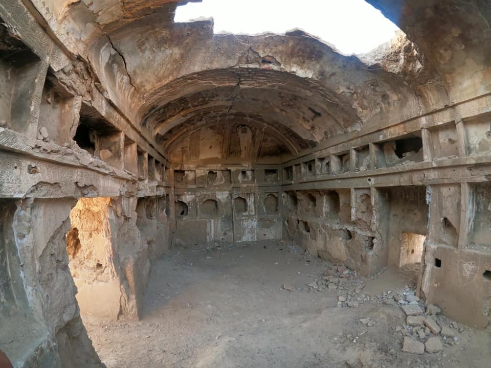
Fast decaying remains of the Kharan tombs
Until 1940, the state of Kharan remained a federating unit of the State of Kalat (princely state). Under the British rule, Kharan remained an independent Sardari (fiefdom) of Kalat State. During the early 1930s, Mr. Wakefield, British political agent in Kalat, wrote in his administrative report to the authorities in New Delhi: ‘Kalat was unique among the Indian States in that the ruler directly administered through his Wazir only about one-third of his territory; the remaining portion was under the control of tribal chiefs known as Sirdars. The State was divided into five provinces. Their name had a romantic flavor of Central Asia; Sarawan, Jhalawan, Kachhi, Mekran and Kharan. The last of these, Kharan, was administered by its own semi-independent Nawab. Each of the other four provinces contained extensive areas, known as Niabats, for the administration of which the Wazir-Azam was responsible. The Sirdars owned allegiance to the Khan, but resented interference by him or by his Wazir.’
The Kharan District has many astounding geographical features such as Koh-e-Maran (the Mountain of Snakes), known to have large deposits of semi-precious stones such as Fluorite, Chlorite Quartz and Brookite. The region also has a sizable deposit of minerals, such as chromite and manganese. The Ras Koh Hills is a range of granite hills forming a southwestern part of the Sulaiman Mountain Range, in the Chaghai and Kharan districts. The word ‘Ras’ means ‘gateway’, and the word ‘Koh’ means ‘mountain’ in Balochi. Ras Koh, therefore, means ‘Gateway to the Mountains’. Plateaus and basins predominate the Ras Koh Hills with an average elevation of 600 meters, but in some areas, the hills can reach an elevation of up to 3,000 meters. In 1962, the Government of Pakistan designated an area of 994.98 kilometers here as Koh Wildlife Sanctuary.
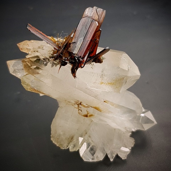
Brookite found from the hills of Kharan
Kharan is also home to sand dunes locally known as ‘Barchan’, some as high as well over 100 feet. Forming the unique Kharan-Chaghai desert, this stretch of unending sand dunes is home to the largest dry lake of Balochistan called Hamun-i-Mashkel. Strong winds continue to add a great amount of sand to this desert, blowing from as far as Afghanistan.
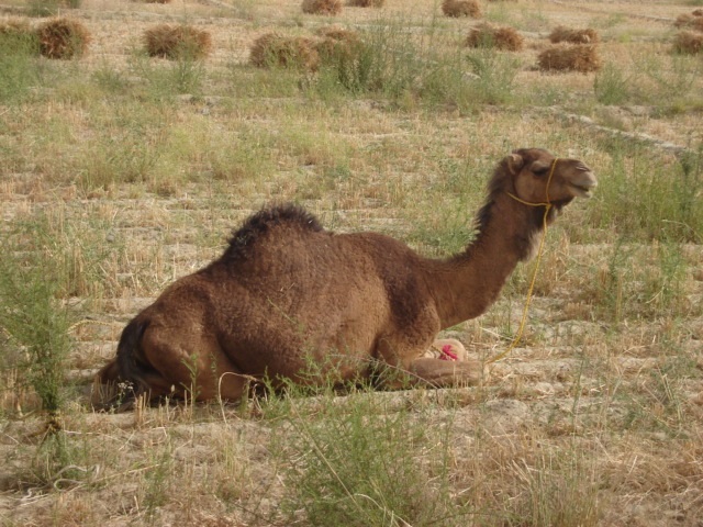
Kharan camel
Almost frozen in time, this is also the land of Kharan camel, one of the most important camel breeds, well adapted to the desert ecosystem. Since ancient times, the Kharan camel plays a pivotal role in the socio-economic and socio-cultural life of the pastoral people of the region. During winters, the nomadic and semi-nomadic owners of these camels migrate to the east, up to the Bolan area of the province. One of the best milk producers in the world, a female camel can produce up to 40 litres of milk per day. This milk is used fresh or soured by the local nomadic tribes. Another unique animal from Kharan is the legendry Morak goat, uncannily close to its wild ancestors, resistant to diseases, and with a strong ability to escape. Badeni, Muhammad Hasani, Maingul, Jamaldini, Sasoli, Sanjrai, Nothezi, Nausherwani, Malangzai, Faqirzai and Hajizai tribes remain proud herders of this unique ruminant. Morak goats are medium in size with black coat, rarely found in white. The male Morak has a distinguished appearance with long curled horns and a beard. The goat also produces up to two litres of milk depending on the availability of vegetation in the desert for grazing.
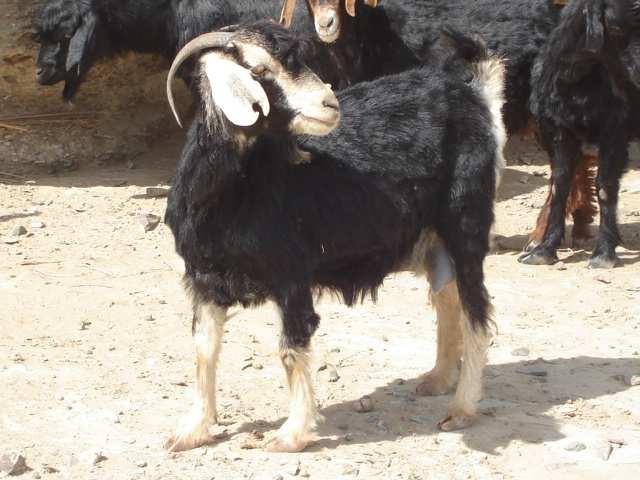
Morak Goat
Within this desert climate, vegetation such as Ghaz, bushes like Hashwarg, Pog, Lara, Kandar and Narronk, and grasses like Mughair, Kash, Righith and Shanaluk abound, providing the fodder for goats and camels. The hills of the district are largely bare, with small patches containing shallow soil. There is a little farming, and the crops grown include wheat, barley, rapeseed, mustard and cumin. Fruits grown include almonds, apples, apricots, grapes, peach, pomegranate, dates, watermelon, and musk melon.
The nearest railway station to Kharan is in Chaghai, although there is a private airport owned by the royal family of Abu-Dhabi in Kharan District. Recently the National Highway Authority’s executive board has approved the construction of a 264 kilometers long Yakmach-Kharan Road, which will link Chaghai with the China Pakistan Economic Corridor (CPEC) route, when it passes through Kharan. It is expected to boost trade and other economic activities in the region.
You may also like: