Written by: Saram Maqbool
Posted on: November 19, 2026 | 

Construction underway at the Diamer-Bhasha Dam
I imagine that for the younger generations of today, it would be very difficult to think that people from centuries ago were able to record their stories and lives in a way that's still being uncovered to this day. Because how would that be possible without instant access to a never-ending repository of data that lives in the cloud? How could people who didn't have access to any devices, or something as seemingly simple as paper, immortalize their lives and stories for us to find lifetimes later?
The rock art of Chilas is one example of human beings using whatever means they had to communicate when the spoken word just wasn't enough. In the Diamer district of Gilgit-Baltistan, this is among the most extraordinary archives in South Asia. Discovered across the banks of the Indus River, these engravings preserve traces of human life and culture spanning thousands of years. The rock faces are covered with drawings of animals, religious figures, stupas, and more, giving us a glimpse into how time shaped human presence in the region. But although we have access to this immense, priceless repository of human history to cherish, its future is uncertain thanks to the construction of the Diamer-Bhasha Dam.
The significance of the Chilas rock art becomes clearer when viewed within its geographical setting. The Upper Indus Valley is located at a point where the Hindu Kush, Himalayan, and Karakoram mountain ranges meet. The river corridor provided one of the few practical routes connecting the Indian subcontinent with Central Asia and other regions further north. Travelers, pilgrims, traders, and soldiers navigated the difficult terrain and left behind traces of their journeys on the rocks. The massive collection we have today doesn’t only show isolated drawings, but rather is the living record of an interconnected world.
And it's not even a small collection either. According to the Heidelberg Academy of Sciences and Humanities, which coordinated a major German-Pakistani research program between 1984 and 2012, there are more than 50,000 rock drawings and over 5,000 inscriptions across approximately 100 kilometers of the Upper Indus Valley. The wider collection spans an exceptionally long period, from prehistoric times to the spread of Islam in the region. The construction of the Karakoram Highway opened the region to proper research and documentation. Over time, the Pak-German research project began with the work of Karl Jettmar and Ahmad Hasan Dani.

The earliest images showed animal and human figures
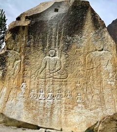
The earliest images showcased animals such as ibex and wild sheep, often with remarkable attention to detail. Over time, the visual language became increasingly diverse, and it brought along engravings of Buddhist stupas, monks, symbolic figures, and more. The Chilas-II site, situated on the left bank of the Indus, is particularly important. According to the Directorate of Archaeology and Museums, it contains early Buddhist imagery, animal figures, human representations, and inscriptions in the Kharoṣṭhī script. Approximately 60 Kharoṣṭhī inscriptions at Chilas II have also been documented by researchers, providing evidence of the language and cultural practices of the period.

Several inscriptions can be found in different languages
These engravings are not simply illustrations of religious belief. They offer evidence of how Buddhism traveled through the mountain corridors and became embedded in local life. Some depictions show monks venerating stupas, while inscriptions record names, titles and journeys. The absence of human representations of the Buddha in certain early scenes has led researchers to associate them with a pre-iconic phase of Buddhist art, in which the stupa itself served as a central symbol of the Buddha's presence.
The inscriptions in languages like Kharoṣṭhī, Brāhmī and Sogdian are equally important. They reveal the movement of people from different cultural and linguistic backgrounds. Near Shatial Bridge, researchers have documented hundreds of Sogdian inscriptions, alongside examples of other Iranian and Indian languages. These records suggest that merchants and travelers from Central Asia were not merely passing through the region but were actively participating in its cultural life. The rocks effectively became a public archive, recording the presence of people who might otherwise have disappeared from written history.

Many Buddhist illustrations have been uncovered
Today, however, like a majority of Pakistan’s historical artifacts, this archive is under serious threat. The most immediate challenge comes from the Diamer-Bhasha Dam, being constructed on the Indus downstream of Chilas. Its reservoir will extend upstream through the Chilas region, overwhelming archaeological sites along the river. Digital surveys and inventories cited by researchers estimate that over 30,000 petroglyphs and nearly 4,000 inscriptions will be submerged when the reservoir is filled. But that’s not the only threat to this priceless archive of human history. Road widening, construction activity, blasting, the extraction of building materials, and unauthorized markings have already damaged archaeological sites. A 2023 study on the Cultural Heritage Management Plan for the dam describes examples of carved boulders being destroyed during road works and notes that modern inscriptions have damaged ancient surfaces.
That said, efforts are being made to mitigate the damage. WAPDA signed a Rs. 46.5 million agreement with Quality Solution Technologies in early 2024 for documenting and digitally modeling significant carvings that fall within the dam’s impact zone. The program includes terrestrial scanning, archiving, and preparing data for possible 3D printing. The plans also propose creating a museum and promoting cultural tourism. As positive as these initiatives are, they will never replace the original archaeological setting and will, at best, be a representation of what used to be.

Some engravings are quite large in scale and very detailed
The challenge, therefore, is not simply to photograph what is about to disappear. It is to establish a more comprehensive approach to heritage conservation. This requires detailed documentation, physical protection of sites outside the inundation zone, trained local custodians, archaeological supervision during construction, and meaningful involvement of the communities living alongside these remains. The best solution would have been to protect these sites from such development in the first place, but we are sadly beyond that point.
The rocks of Chilas have survived climatic changes and the rise and fall of civilizations. They tell the stories of everyone from kings and empires to common folk and traders. Their value goes far beyond just their visual identity, but is tied to their relationship with the river. Recreating them digitally is not the ideal solution, but at this point it might be the only thing we can achieve. A dam may generate electricity for generations, but the cultural record it submerges cannot be recreated. Pakistan's development must not come at the cost of forgetting the people and histories that shaped its landscape. The preservation of Chilas is not an argument against progress, but rather a reminder that progress should also know what is worth protecting.
You may also like: